
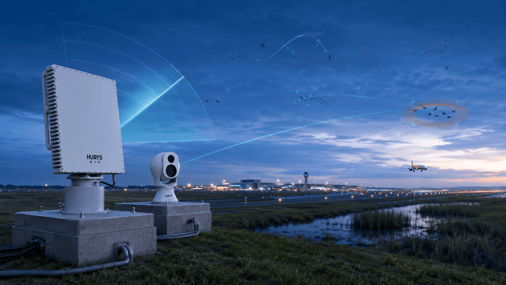
Airport Bird Strike Prevention Detection System
All-weather bird detection,Three-dimensional flight tracking,Bird-activity risk analysis,Precision bird-control support
Bird activity around runways, taxiways, approach and departure corridors, grasslands, drainage areas, and airport boundaries can create rapidly changing hazards to aircraft operations. Visual patrols and scheduled bird surveys remain essential, but they cannot continuously measure every flight path, altitude change, flock movement, or nocturnal activity across the airport environment. The HURYS Airport Bird Strike Prevention Detection System combines bird-detection radar, dual-spectrum electro-optical tracking, edge intelligence, and a dedicated bird-activity management platform to detect, track, verify, and analyze birds in three dimensions. It transforms live trajectories and historical activity records into graded warnings, risk-area heatmaps, altitude and time distributions, movement-corridor analysis, and targeted bird-control guidance—supporting earlier and more evidence-based bird-strike prevention.
The solution establishes continuous bird-risk awareness across airport movement areas and surrounding protection airspace. Radar measures bird and flock position, altitude, speed, direction, and trajectory without depending on ambient lighting. A radar-cued dual-spectrum electro-optical unit provides visible and thermal imagery for selected targets, while edge processing filters environmental clutter and associates track and image evidence. The platform evaluates activity by zone, altitude, direction, density, persistence, time, and historical pattern, helping airport wildlife-management teams identify developing risk, prioritize inspections, and deploy approved bird-control resources where and when they are most effective.
From Reactive Dispersal to Continuous Bird-Risk Awareness
Conventional airport bird control often begins when a patrol observes birds near a runway or receives a report. By that time, the flock may already be moving toward an aircraft movement area, while birds flying at night, above the observer’s line of sight, or beyond the current patrol sector may remain undetected. The result is a response driven by isolated sightings rather than a continuous understanding of bird behavior.
HURYS introduces a radar-electro-optical approach centered on persistent bird-risk awareness. Bird-detection radar continuously scans configured airport airspace and generates three-dimensional tracks. When a bird or flock enters a warning zone, crosses a movement corridor, changes altitude, or exhibits another configured risk condition, the system can direct the electro-optical unit to the target for visible or thermal confirmation. Qualified activity is assessed, recorded, and presented to authorized bird-control personnel with its location, trajectory, altitude, direction, and warning level.
This moves bird-strike prevention upstream—from reacting to birds already on the airfield to understanding how bird activity is developing before it reaches the most critical operating areas.
System Architecture
The solution integrates wide-area bird sensing, long-range optical confirmation, edge assessment, bird-activity applications, and approved operational response in a layered architecture. Bird Sensing Layer — A mechanically scanning or phased-array bird-detection radar continuously monitors configured airport airspace and reports target position, altitude, speed, direction, and trajectory. The radar is installed on an engineered ground foundation with coverage designed around runway orientation, approach and departure corridors, terrain, buildings, vegetation, water bodies, and local bird activity. Electro-Optical Verification Layer — A separate dual-spectrum electro-optical tracking unit is installed with an unobstructed field of regard. Radar coordinates automatically cue visible and thermal imaging to selected birds or flocks for observation, recording, and target confirmation. Edge Intelligence Layer — An edge computing unit associates radar tracks with optical imagery, filters weather and environmental clutter, evaluates track quality, and applies bird-target and flock-behavior rules. Local processing reduces latency and forwards qualified records to the central platform. Bird-Activity Platform Layer — The platform displays live three-dimensional tracks, warning zones, flight-direction patterns, altitude bands, activity density, and device status on an airport GIS view. It stores qualified records and produces hourly, daily, seasonal, and multi-year bird-activity analysis. Warning and Bird-Control Layer — Risk events are delivered to authorized wildlife-management and airport operations terminals with location, altitude, trajectory, risk level, and available imagery. Subject to approved airport procedures and interfaces, personnel can coordinate acoustic, visual, vehicle-mounted, or other authorized bird-control resources and record the action and outcome. Operational flow: continuous bird detection → three-dimensional tracking → radar-cued optical confirmation → edge qualification → risk analysis and graded warning → targeted bird-control action → outcome recording and strategy review.
Challenges and Applications
Airport bird-strike prevention must identify where birds are, how they are moving, and when their activity intersects with critical aircraft operating areas—across changing weather, seasons, and habitat conditions. Operational Challenges Wide and three-dimensional monitoring space — Birds may approach from beyond the airfield boundary, cross runways at different altitudes, or follow routes that are not visible from a patrol position. Rapidly changing flock behavior — Flocks can form, disperse, turn, climb, descend, or move between feeding, roosting, and water areas within a short period. Night and reduced visibility — Darkness, fog, haze, glare, and long viewing distance limit visual-only detection and make altitude estimation difficult. Small targets in complex airport clutter — Bird tracks must be extracted from weather, insects, vegetation, buildings, ground movement, and other environmental returns. Seasonal and species-related variation — Bird abundance, flock size, preferred altitude, movement direction, and risk level change by species group, season, weather, habitat, and time of day. Reactive and broad-area deterrence — Bird-control teams need precise target location and movement information to avoid inefficient patrols or unnecessary wide-area dispersal. Fragmented records and limited trend insight — Sightings, dispersal actions, strike records, habitat observations, and radar tracks are often stored separately, limiting long-term analysis. What These Challenges Require These conditions call for continuous all-weather sensing, three-dimensional bird and flock tracking, configurable runway and flight-corridor risk zones, radar-cued visible and thermal verification, environmental clutter filtering, bird-activity risk scoring, graded warnings, precise bird-control support, operational outcome recording, and long-term spatiotemporal analysis. HURYS connects these capabilities as one detection-to-prevention workflow. Typical Applications Runway and taxiway surroundings — Monitors birds crossing, approaching, or remaining near critical aircraft movement areas. Approach and departure corridors — Tracks bird altitude, direction, and movement intensity in configured low-altitude flight corridors. Airport grasslands and drainage areas — Identifies activity around feeding, resting, and water-attracting locations within the airport environment. Boundary and surrounding habitat interfaces — Observes bird movement between off-airport habitat and protected operating areas. Nighttime and seasonal migration periods — Provides continuous trajectories and activity statistics during high-risk time windows that are difficult to survey visually. Bird-control operation assessment — Compares activity before, during, and after approved dispersal actions to evaluate response and refine deployment strategies.
All-Weather Three-Dimensional Bird Detection and Tracking
Bird-detection radar continuously monitors configured airport airspace and measures each qualified bird or flock track in three dimensions. Position, altitude, speed, direction, trajectory, persistence, and track concentration provide a dynamic picture of how birds approach, cross, or remain near runways, taxiways, approach and departure corridors, and habitat-attracting areas.
Software-defined observation zones can represent an outer awareness area, an airport boundary, a runway warning zone, an approach or departure corridor, an altitude band, or another locally defined risk area. Edge processing evaluates tracks against these spatial and behavioral rules while filtering unstable returns associated with weather, insects, vegetation, buildings, and ground clutter. Sensor placement and coverage are engineered for the selected radar, runway layout, local terrain, structures, bird target set, and required detection performance.
The platform presents live tracks and warning conditions on the airport map, allowing wildlife-management teams to see not only that birds are present, but where they came from, how high they are flying, which direction they are moving, and whether their trajectories are converging with a critical area.
Bird-Risk Analytics and Precision Deterrence Support
A bird track becomes operationally meaningful when it is interpreted in the context of airport risk. The system evaluates location, altitude, direction, speed, persistence, flock characteristics, zone entry, activity density, time of day, and historical patterns. Where approved operational data are integrated, current aircraft movement context can further support risk prioritization. The output is a graded bird-risk event rather than an isolated detection.
For selected targets, the radar directs the dual-spectrum electro-optical unit to the bird or flock coordinates. Visible and thermal imagery supports confirmation, observation, and—where image quality and validated models permit—species-group assessment. Operators receive the target location, altitude, trajectory, risk zone, warning level, and available imagery in one operating view.
Based on approved airport procedures, bird-control teams can deploy the most appropriate acoustic, visual, vehicle-mounted, or other authorized measure to the relevant area. The system records the warning, action, response time, target movement, and post-action result. Over time, these records generate activity heatmaps, altitude profiles, time-series curves, movement corridors, high-risk periods, and deterrence-effect comparisons—helping airports move from broad reactive dispersal toward targeted and continuously optimized bird-control operations.
Problems We Solve in Airport Bird-Strike Prevention
HURYS combines three-dimensional bird detection, optical verification, edge assessment, bird-risk analytics, warning workflows, and bird-control records to address the principal gaps in conventional airport bird-strike prevention. Bird activity outside patrol sightlines — Wide-area radar sensing supplements visual patrols and maintains awareness across configured airport airspace. No reliable altitude or trajectory information — Three-dimensional tracks show flight height, direction, speed, persistence, and convergence with critical areas. Late discovery near runways — Outer awareness and corridor zones identify developing bird activity before it reaches the highest-risk operating area. Night and poor-visibility blind periods — Radar maintains sensing in darkness and conditions that reduce conventional imaging performance. Raw detections without risk context — Zone, altitude, direction, flock, density, time, and historical rules convert qualified tracks into graded bird-risk events. Broad and inefficient bird-control deployment — Precise location, trajectory, and optical evidence help teams direct approved measures to the relevant target and area. Dispersal actions without effectiveness feedback — Pre-action and post-action tracks, response times, and outcomes support evaluation and strategy refinement. Fragmented bird-activity records — A unified database connects live tracks, warnings, imagery, control actions, strike-related records, habitat observations, and long-term trends where data are available. The result is earlier bird-risk awareness, clearer operational priorities, more targeted bird-control action, measurable response outcomes, and a stronger evidence base for continuous bird-strike risk reduction.
HURYS Makes Airport Airspace Truly 'Safer'
Bird-strike prevention becomes more effective when an airport can understand not only where birds are now, but where and when hazardous activity is most likely to develop. HURYS connects real-time trajectories with long-term bird-activity patterns, turning observation into forward-looking safety intelligence.
Core Value: From visual sightings to continuous three-dimensional awareness — Radar reveals bird and flock location, altitude, direction, and movement across configured airport airspace. From isolated tracks to graded bird-risk events — Spatial, behavioral, temporal, and historical factors help prioritize the activity that matters most. From manual search to radar-cued optical evidence — Dual-spectrum tracking brings selected birds and flocks into view for faster assessment. From broad dispersal to precision bird control — Actionable location and trajectory data help teams deploy approved resources where and when they are needed. From completed actions to measurable outcomes — Before-and-after tracks and handling records show how bird activity changed following intervention. From seasonal experience to predictive risk intelligence — Long-term heatmaps, altitude profiles, movement corridors, and high-risk periods support earlier planning and resource allocation. By connecting continuous bird detection, three-dimensional tracking, optical evidence, risk analytics, targeted bird control, and long-term patterns, HURYS turns bird-strike prevention from reactive dispersal into predictive, evidence-based safety management.